This year, route markings on the street with arrows are being replaced by:
Downloadable bike routes available via Ride with GPS cycling navigation mobile app
Ride with GPS mobile app includes turn-by-turn voice directions, cue sheets and maps for all routes
Printed copies of the route sheets and maps still available on day of the ride
Please note routes may be updated or changed due to unforeseen circumstances at anytime prior to the event day
The Tour de Menlo website is your best source for current route information
More details coming soon on downloading Ride with GPS and routes to your phone or Garmin type device
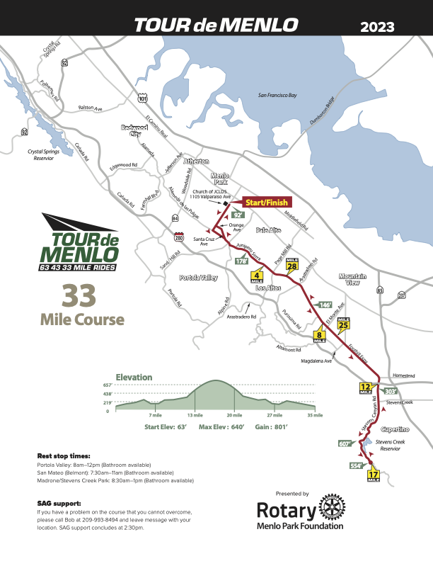
33 Mile Route
This is the perfect route for beginners or riders who prefer an easy, virtually flat ride down the Peninsula. From the start at The Church of Jesus Christ of Latter-Day Saints at 1105 Valparaiso Ave. in Menlo Park, the course heads out Valparaiso to the Alameda de las Pulgas, turns south across the Stanford campus and then stays on Foothill Expressway (with one water stop) all the way to Stevens Canyon Road and the Madrone Park rest stop. Then you will retrace your route back to the starting point and a delicious lunch. With an estimated total elevation gain of only 500 feet, this is a perfect course for riders who are not interested in hills.
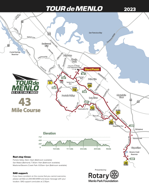
This more challenging route takes riders to the Alameda de las Pulgas and then north, to Woodside Road. Pass Interstate 280 on the climb up to Whiskey Hill Road. Riders will turn left onto Whiskey Hill Road and then right onto Sand Hill Road. Sand Hill Road will become Portola Road and, after a scenic ride through Portola Valley, riders will arrive at new rest stop at the Christ Church overflow parking lot, adjacent to the Portola Valley Town Center. After a brief rest, riders continue on Portola Road, turn left onto Alpine Road and then turn right onto Arastradero Road at the historic Alpine Inn. The course will wind around Arastradero Road, with a short jaunt on Page Mill Road, and then into Los Altos, starting with a right turn on Purissima leading to some short climbs on Robleda, Elena and on to Foothill College. From there, the route winds its way back to Foothill Boulevard and on to Stevens Canyon Road and then to beautiful Madrone Park, where we turn around and retrace our route back to The Church of Jesus Christ of Latter-day Saints in Menlo Park via Foothill Boulevard. The estimated elevation gain for this route is a comfortable 1,200 feet.
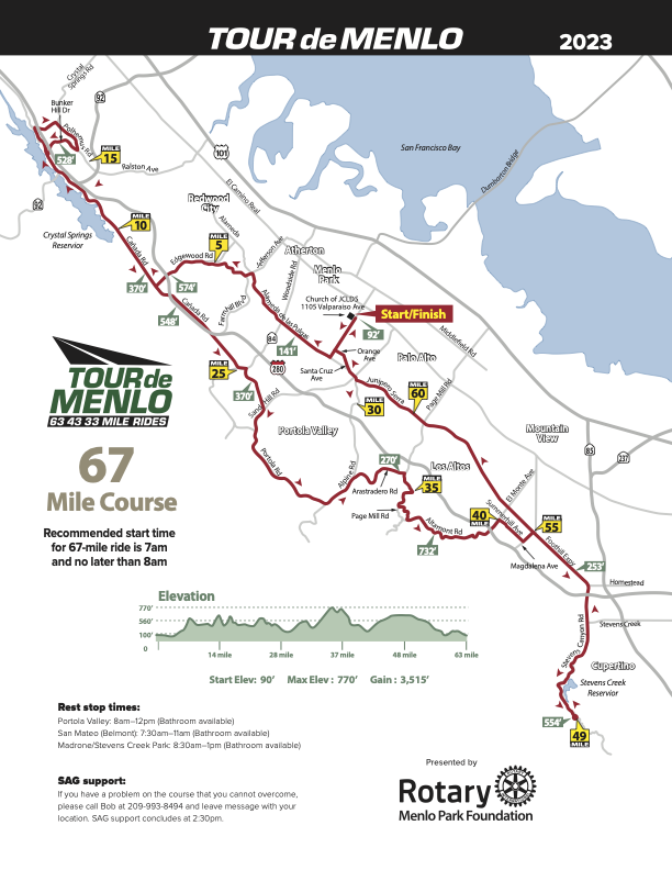
The Tour’s most challenging route takes riders north on the Alameda de las Pulgas to a half-mile climb up Edgewood Road, and then north on Canada Road, crossing Highway 92, and to Bunker Hill Rd. Watch for the water/rest stop on Polhemus Road. After a brief rest stop, riders will retrace their route on Polhemus Road, traveling north on Polhemus and then turn left on Crystal Springs Road to Skyline Road (35), where they turn left. After traveling a few hundred yards on Skyline Road, riders turn right onto a bike path that parallels Skyline for a mile or so and rejoins Skyline to get to Half Moon Bay Road (92). Riders turn left onto Half Moon Bay Road and then make a slight right onto Canada Road, taking them back to Woodside. Following a short climb to Whiskey Hill Road, riders will link up with the 43 Mile route, heading west to Portola Road and to a new rest stop at the Christ Church overflow parking lot, adjacent to the Portola Valley Town Center. After a brief rest, riders continue on Portola Road, turn left onto Alpine Road and then turn right onto Arastradero Road at the historic Alpine Inn, taking them to Los Altos. After some short climbs, riders will turn right on Foothill Boulevard and head for Madrone Park, a rest stop and turnaround point where we begin the return to the start and a delicious lunch at The Church of Jesus Christ of Latter-day Saints in Menlo Park via Foothill Boulevard and Valparaiso Road.
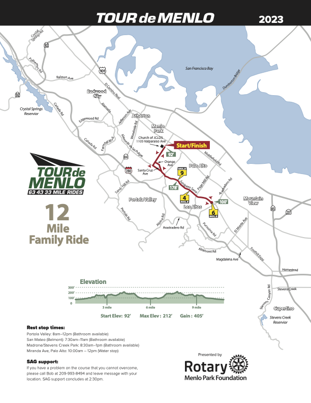
The Tour’s newest route for those that are not avid cyclists or wish to do the ride with their families. This route is the same as the 33 mile route except riders will turn around at the Los Altos rest stop. The ride will start at The Church of Jesus Christ of Latter-Day Saints at 1105 Valparaiso Ave. in Menlo Park. The course heads out Valparaiso to the Alameda de las Pulgas, turns south across the Stanford campus and then stays on Foothill Expressway. Riders will retrace their route back to the starting point and a delicious lunch. With an estimated total elevation gain of only 500 feet, this is a perfect course for riders who are not interested in hills.